Mount Roraima
07-06-2021
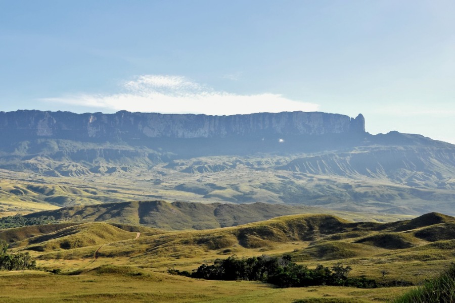
Mount Roraima, located on the triple border between Brazil, Venezuela and Guyana, is a tepui, a plateau-shaped mountain delimited by cliffs that form impregnable vertical rock faces about 1,000 meters high. Mount Roraima, discovered by Europeans in 1595 during the Spanish and British colonization of this part of South America, remained unexplored until the end of the 19th century. The "crystal mountain" from which many waterfalls sprang was considered impossible to climb and was the subject of many legends and stories, notably serving the imagination of Sir Arthur Conan Doyle for his 1912 book "The Lost World" , which later inspired many adventure films. During the 19th century, adventurers in search of the Eldorado and numerous scientific expeditions sponsored by the Royal Geographical Society and led by British and German scientific explorers, specialists in the local flora, fauna and avifauna , made repeated incursions into this region inhabited for at least 10,000 years by Amerindian peoples, now by the Pemons, descendants of the Caraibas, established in the region about 300 years ago, who all declared the top of the cliffs inaccessible and pristine since the beginning of the world. In 1872, the British geologist Charles Barrington Brown even proposed a hot air balloon ascent to the mountain. Another expedition, led by Flint and Edginton, reached Mount Roraima in 1877 and also declared the impenetrable nature of the cliffs to the north, east and south. Henry Whitely, who has studied the region's avifauna, opined that the summit of the mountain could be reached from the south face using ropes and ladders - unlike his neighbor Tepui Kukenán, whose highest point seemed be accessible only by balloon from the southeast, due to prevailing winds. Eventually, Mount Roraima was the first great tepui to be climbed, by Everard im Thurn and Harry Perkins who led an expedition sponsored by the Royal Geographical Society and reached the summit on December 18, 1884. The team spotted a passage previously unknown of the Pemons Indians. The mountainous plateau presents an environment totally different from the tropical forest and the savannah which extend to its feet. The flora has adapted to these different climatic and geological conditions with a high degree of endemism, including several species of carnivorous plants - which remove the nutrients they lack in the soil from captured insects. The fauna is also characterized by marked endemism, especially in reptiles and amphibians. The high rainfall index favored the formation of many caves. The caves began to be explored by Venezuelan cavers in the late 1930s and, especially since the 1970s. Their work shows that underground cavities, in addition to their large dimensions, can form in quartz rocks. This environment is protected in Venezuela by the magnificent Canaima National Park and in Brazil by the Monte Roraima National Park entirely inserted in the indigenous land Raposa Serra do Sol, one of the largest indigenous lands in the country, with 1,743,089 hectares and 1,000 kilometers of perimeter (about half of Belgium). For this reason, the park is managed by the National Indian Foundation, the Chico Mendes Institute for the Conservation of Biodiversity (ICMBio) and the Ingaricós Indian community. The summit rises in the extreme south, in the Venezuelan state of Bolivar, at an altitude of 2,810 meters. The second highest point, with 2,772 meters, is located north of the plateau, in Guyanese territory. With the development of tourism in the region, especially from the 1980s, Mount Roraima has become one of the most popular destinations for hikers, due to its unique environment and its relatively easy conditions of access and climbing.